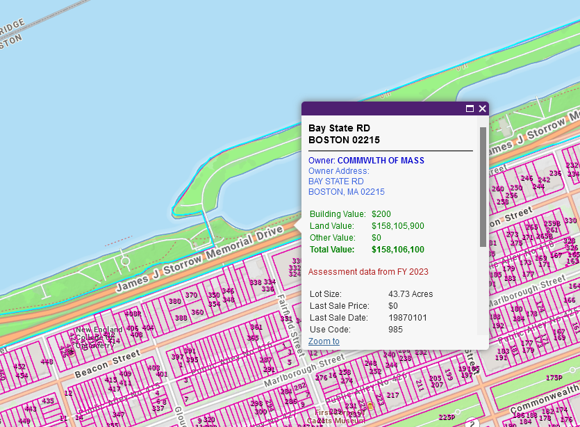
If you want to hold the owner of a road accountable, the first step is figuring out who actually owns a particular road. The Geographic Information System (GIS) is a useful tool. The Massachusetts Interactive Property Map on MassGIS is currently the best tool to determine the owner of a road. The steps are as follows:
- Click on the road.
- Make sure the road is highlighted. Sometimes it highlights an adjacent property.
- If you cannot highlight the road itself, it is owned by the city.
- If the owner shows up as COMMWLTH OF MASS, it is a state owned road.
The following is a non-comprehensive list of roads owned by the Commonwealth of Massachusetts:
- Boston–Providence Highway (Dedham)
- George Washington Boulevard (Hingham, Hull)
- General Casimir Pulaski Skyway (Boston)
- John F. Kennedy Memorial Highway (New Bedford)
- Kosciuszko Circle (Boston)
- Leominster Connector (Leominster)
- Leverett Circle Connector (Boston)
- Lowell Connector (Chelmsford, Lowell)
- Plimoth Patuxet Highway (Plymouth)
- Sandwich Road (Bourne)
- Soldiers Field Road (Boston)
- Storrow Drive (Boston)
- State-numbered routes
- Interstate highways: I-84, I-90, I-91, I-93, I-95, I-190, I-195, I-290, I-291, I-295, I-391, I-395, I-495
- United States Numbered Highway: US-1, US-5, US-6, US-7, US-20, US-44
- Wallum Lake Road (Douglas)
- William J. Day Boulevard (Boston)
- William T. Morrissey Boulevard (Boston)